 Working Group of the Arctic Council
Featured Maps & Graphics
-
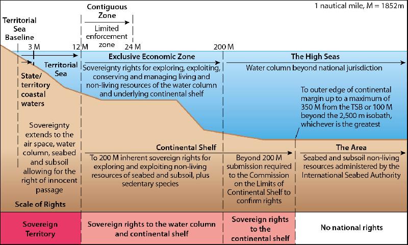 Figure 9.2 Diagram of marine jurisdictional zones (from Symonds et al., 2009;...
Publication: Adaptation Actions for a Changing Arctic: Perspectives from the Baffin Bay/Davis Strait Region
Page number: 251
Type: Schematic
Copyright: Arctic Monitoring and Assessment Programme (AMAP)
Cartographer / Designer: Burnthebook.co.uk
-
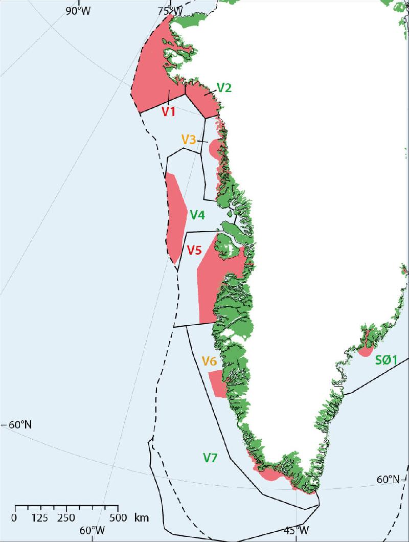 Figure 9.3 Identification of ecologically valuable and sensitive sea areas in...
Publication: Adaptation Actions for a Changing Arctic: Perspectives from the Baffin Bay/Davis Strait Region
Page number: 253
Type: Map
Copyright: Arctic Monitoring and Assessment Programme (AMAP)
Cartographer / Designer: Burnthebook.co.uk
-
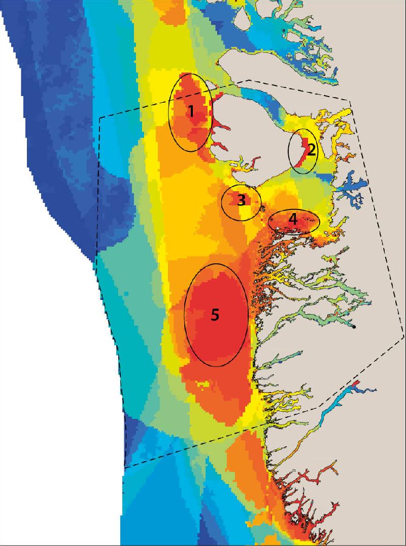 Figure 9.4 Relative environmental sensitivity within the Disko Bay and Store...
Publication: Adaptation Actions for a Changing Arctic: Perspectives from the Baffin Bay/Davis Strait Region
Page number: 253
Type: Map
Location: Disko Bay, Store Hellefiskebanke
Copyright: Arctic Monitoring and Assessment Programme (AMAP)
Cartographer / Designer: Burnthebook.co.uk
-
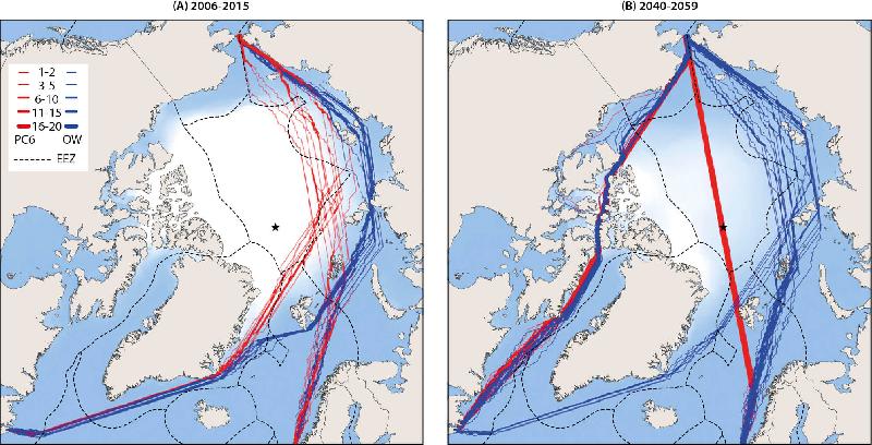 Figure 9.5 Map of optimal Arctic September shipping routes from the Pacific to...
Publication: Adaptation Actions for a Changing Arctic: Perspectives from the Baffin Bay/Davis Strait Region
Page number: 256
Type: Map
Location: circumArctic, circum-arctic, Arctic,
Copyright: Arctic Monitoring and Assessment Programme (AMAP)
Cartographer / Designer: Burnthebook.co.uk
-
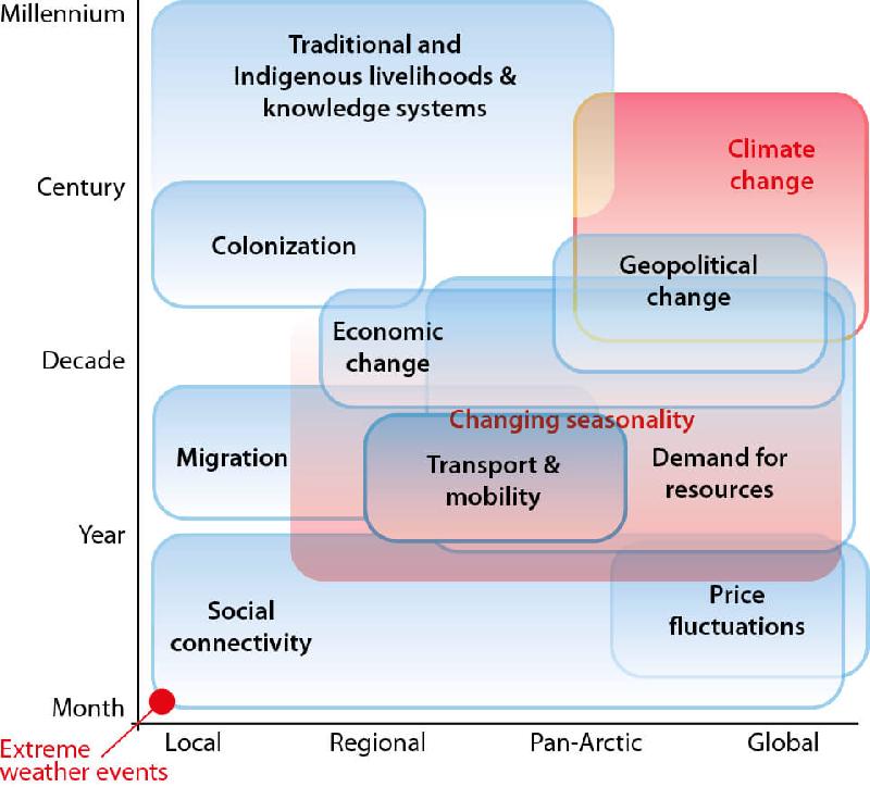 Figure A. Some socio-economic drivers (blue boxes) and climatic drivers (red)...
Publication: Adaptation Actions for a Changing Arctic: Perspectives from the Baffin Bay/Davis Strait Region
Page number: xi
Type: Schematic
Copyright: Arctic Monitoring and Assessment Programme (AMAP)
Cartographer / Designer: Burnthebook.co.uk
-
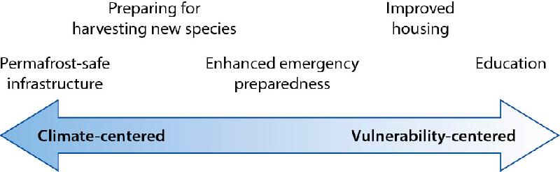 Figure B. Adaptation options can be related to the changing patterns of climate...
Publication: Adaptation Actions for a Changing Arctic: Perspectives from the Baffin Bay/Davis Strait Region
Page number: xi
Type: Schematic
Copyright: Arctic Monitoring and Assessment Programme (AMAP)
Cartographer / Designer: Burnthebook.co.uk
-
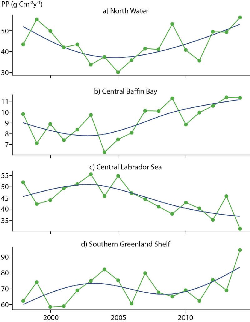 Figure 6.4 Temporal trends in satellite-based primary production, 1998–2014,...
Publication: Adaptation Actions for a Changing Arctic: Perspectives from the Baffin Bay/Davis Strait Region
Page number: 144
Type: Graph
Location: Smith Sound, North Water, Baffin Bay, Labrador Sea, Southwest Greenland, SW, south-west,
Copyright: Arctic Monitoring and Assessment Programme (AMAP)
Cartographer / Designer: Burnthebook.co.uk
-
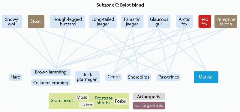 Figure 6.5 Generalized terrestrial food web. The lines represent major trophic...
Publication: Adaptation Actions for a Changing Arctic: Perspectives from the Baffin Bay/Davis Strait Region
Page number: 154
Type: Schematic
Location: Bylot Island, Nunavut, Canada
Copyright: Arctic Monitoring and Assessment Programme (AMAP)
Cartographer / Designer: Burnthebook.co.uk
-
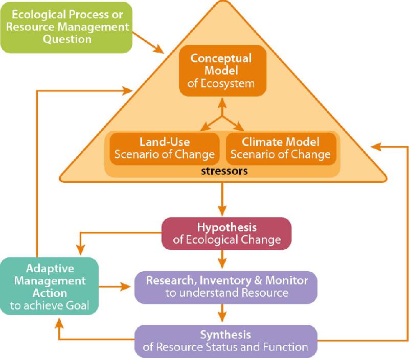 Figure 6.6 Conceptual model for science-based management of natural resources...
Publication: Adaptation Actions for a Changing Arctic: Perspectives from the Baffin Bay/Davis Strait Region
Page number: 159
Type: Schematic
Copyright: Arctic Monitoring and Assessment Programme (AMAP)
Cartographer / Designer: Burnthebook.co.uk
-
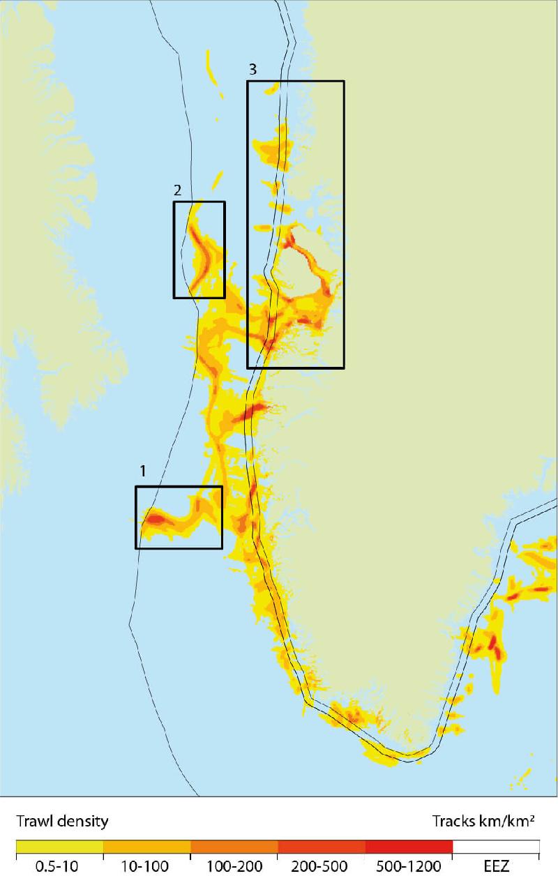 Figure 6.7 Distribution and intensity of the trawl fishery in West Greenland...
Publication: Adaptation Actions for a Changing Arctic: Perspectives from the Baffin Bay/Davis Strait Region
Page number: 165
Type: Map
Location: Baffin Bay, Davis Strait region, BBDS, Canada, Greenland,
Copyright: Arctic Monitoring and Assessment Programme (AMAP)
Cartographer / Designer: Burnthebook.co.uk